An arduous journey back home for Formosan Landlocked Salmon
May 10, 2022
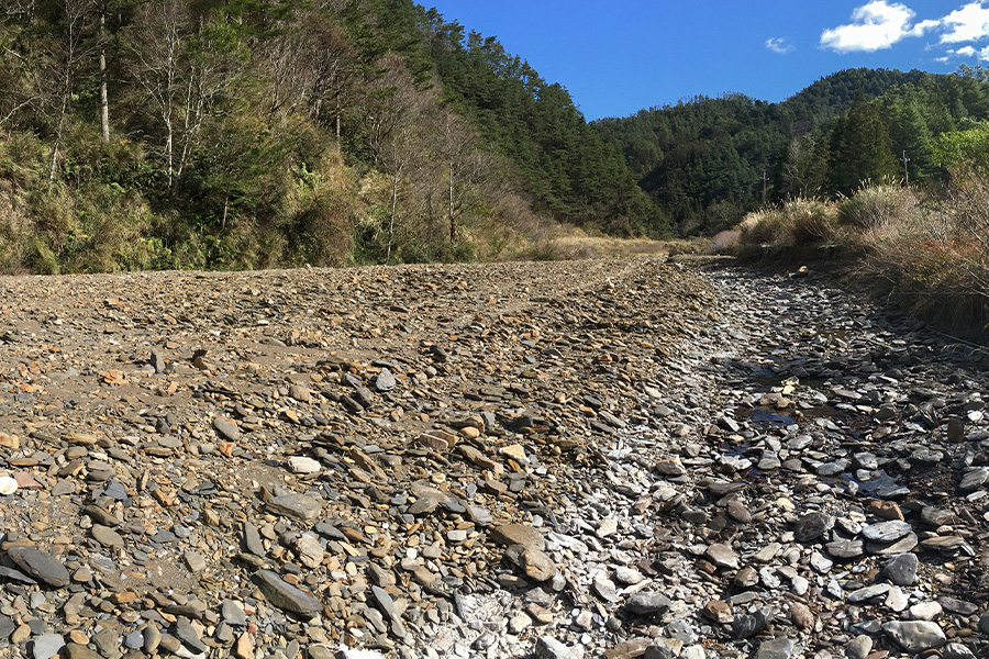
(This report is provided by Dr. Lee’s research team in the Department of Geography) The Formosan landlocked salmon is a critically endangered species also known as the Taiwanese ‘national treasure fish.’ In recent years, the fish was stocked into Rahaw Creek (upper Yusheng Creek, Yilan), where a sustainable group had been successfully rehabilitated. Lately, however, frequent stream fragmentation events in Yusheng Creek have prevented the fish from expanding their habitat, killing many as a result. To understand the reasons for the fragmentation and to improve rehabilitation, the research team installed six monitoring wells across a 500-meter fragmented reach to record temperatures and groundwater levels, which allowed them to understand surface water-groundwater interactions over different periods. The findings showed that compared to the perennial ones, the fragmented reach is of significantly higher streambed vertical hydraulic conductivity, causing the water to infiltrate the streambed at higher speeds. The findings also indicated that the vertical hydraulic conductivity was influenced by discharge, rainfall changes and the remains of dead diatoms. Most fragmentation studies focus on streams in semi-arid climates. This paper not only demonstrates the uniqueness of how mountain stream discharge in humid subtropical climates is affected by hydrological conditions and bioactivities, but also sheds light on the complexity of surface water-groundwater interactions by examining temporal variations in hydraulic conductivity. There is no doubt that fragmentation of a stream would impact its ecosystem, as no fish would be able to survive in a river without stream flow. The Taiwanese “national treasure” Formosan landlocked salmon is a cold-water fish native to Chichiwan Creek. Once at the brink of extinction, the fish population in mainstem Chichiwan Creek has since been stabilised thanks to the joint efforts of the Shei-Pa National Park Administration along with many other professionals. The salmon was stocked into its historical habitats, with Rahaw Creek (upper Yusheng Creek) being the most successful one as the fish were shown to expand downstream towards Yusheng Creek. However, the watercourse of Yusheng Creek was drastically altered and began showing frequent fragmentations in the wake of a flash flood caused by a typhoon in 2012. Instead of flowing along the surface, much of the river water infiltrated the streambed and became groundwater. The dried-up watercourse limited the salmon’s expansion of habitat to the point that their way back upstream became cut off, leaving them stranded downstream in an unsuitable habitat. In the hope of improving rehabilitation under the support of the “Shei-Pa National Park Project,” a team of experts from the Department of Geography at NTNU, Institute of Earth Sciences at NTOU, Department of Bioenvironmental Systems Engineering at NTU, and the Wuling Workstation of Shei-Pa National Park Administration set out to understand the reasons for the fragmentations by installing 6 monitoring wells across a 500-metre reach in the fragmented reaches to record temperatures and groundwater levels. This allowed them to gain insights into surface water-groundwater interactions over different time periods. The findings were published in the Journal of Hydrology (https://doi.org/10.1016/j.jhydrol.2020.124665). Since it is not possible to directly measure surface water-groundwater flow, the research team utilised ‘heat’ as a natural tracer. By monitoring the thermal activity of the cross-sectioned streambed through the wells, and comparing the water level of the stream against that of the wells, the researchers were able to see how the water was moving within the streambed. When the water level of the stream is higher than that of the wells, the water begins to infiltrate the streambed. The temperature of the streambed would thus show how much heat is passing downwards. Therefore, reaches with stronger infiltration (high water levels in the stream compared to the wells) would show similar thermal changes between ground and surface water. Conversely, reaches with weaker infiltration would show dissimilar temperature records in the streambed compared to that of the surface. By examining the thermal cross sections of the streambed, the vertical speed of water in the streambed, or hydraulic conductivity, could thus be learned. The findings showed that compared to the perennial ones, the fragmented reaches have significantly higher streambed hydraulic conductivity, meaning that the water was infiltrating the streambed at higher speeds. It is typical that hydraulic conductivity in perennial reaches should be doubled after rainfall as higher volumes of discharge remove sedimentation clogged within the streambed. With fragmented reaches, the vertical hydraulic conductivity of the streambed continued to drop by approximately 50-75%. The team then realized that the surfaces of reaches were waterless before rainfall events, and the dryness led to the death of large volumes of diatoms that grow in the stream, the remains of which were left deposited on the surface of the sediments (Figure 1), which is the speculated reason for the decrease in hydraulic conductivity. This suggests that the growth and death of diatoms could be the key to decreasing fragmentation events in streams. This fragmented reach was previously a perennial one. Aside from cutting off the way home for the Formosan landlocked salmon, it is also worth continuous study on how such events impact the river’s ecosystem, including the proliferation and death of diatoms before and during the fragmentation period, and the transmission of matters after the streamflow recovers. Figure 1. (Left) Dead diatoms scattered across the dry river course, (mid) a close-up of the riverbed and (right) diatoms under an electron microscope. Reference: Chiu, Y.C., Lee T.Y., Hsu, S.Y., Liao, L.Y., 2020. The effects of hydrological conditions and bioactivities on the spatial and temporal variations of streambed hydraulic characteristics at the subtropical alpine catchment. Journal of Hydrology, 584, 124665. https://doi.org/10.1016/j.jhydrol.2020.124665

